

Arctic Report Card Errata
Arctic Report Card errata.
Arctic Report Card Errata Read More »
Archive of the entire 2019 Report Card website.
Arctic Report Card 2019 Read More »
The Arctic Report Card (hereafter ‘ARC’) has been issued annually since 2006. It is a timely and peer-reviewed source for clear, reliable and concise environmental information on the current state of different components of the Arctic environmental system relative to historical records. The ARC is intended for a wide audience, including scientists, teachers, students, decision-makers, policy-makers, and the general public interested in the Arctic environment and science.
About Arctic Report Card 2019 Read More »

The Bering Sea is the third largest semi-enclosed sea in the world and forms the transition between the subarctic North Pacific Ocean and the Arctic Ocean. This article focuses on the eastern shelf, which has an exceptionally productive ecosystem, supporting large numbers of seabirds and marine mammals, subsistence harvests for native communities across Alaska, and more than 40% of the annual U.S. catch of fish and shellfish.
Recent Warming in the Bering Sea and Its Impact on the Ecosystem Read More »

The Arctic continues to warm at a rate that is currently twice as fast as the global average. Warming is causing perennially-frozen ground (permafrost) to thaw, with permafrost in many locations currently reaching record high temperatures. Organic carbon contained in soils of the permafrost region represent a climate-sensitive carbon reservoir that is affected by warming air and ground temperatures and permafrost thaw.
Permafrost and the Global Carbon Cycle Read More »

The Bering Sea is home to over 70 Indigenous communities of the Iñupiat, Central Yup’ik, Cup’ik, St. Lawrence Island Yupik, Unangan, and Chukchi Peoples. We are peoples of the world’s richest sea. We study the ocean and weather as a way of life, as a means for survival. The Bering Sea is undergoing changes that have never been observed in our lifetimes, but were foreseen by our elders decades ago.
Voices from the Front Lines of a Changing Bering Sea Read More »
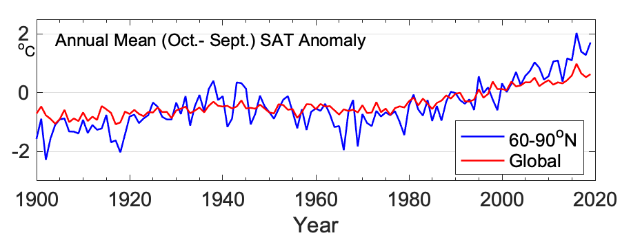
Arctic surface air temperature is an indicator of both regional and global climate change. Although there are year-to-year and regional differences in air temperatures, driven by natural variability, the magnitude, persistence, and Arctic-wide patterns of recent temperature increases are indicators of global climate change from increasing concentrations of atmospheric greenhouse gases. Warming atmospheric temperatures also act as a driver of Arctic changes in the ocean and on land.
Surface Air Temperature Read More »