
T. A. Moon1,2, K. D. Mankoff1,2, R. S. Fausto3, X. Fettweis4, B. D. Loomis5, T. L. Mote6, K. Poinar7, M. Tedesco8,9, A. Wehrlé10, and C. D. Jensen11
1National Snow and Ice Data Center, University of Colorado Boulder, Boulder, CO, USA
2Cooperative Institute for Research in Environmental Sciences, University of Colorado Boulder, Boulder, CO, USA
3Geological Survey of Denmark and Greenland, Copenhagen, Denmark
4SPHERES Research Unit, University of Liège, Liège, Belgium
5Goddard Space Flight Center, NASA, Greenbelt, MD, USA
6Department of Geography, University of Georgia, Athens, GA, USA
7Department of Geology, University at Buffalo, Buffalo, NY, USA
8Lamont-Doherty Earth Observatory, Columbia University, Palisades, NY, USA
9Goddard Institute of Space Studies, NASA, New York, NY, USA
10Department of Geography, University of Zurich, Zurich, Switzerland
11Danish Meteorological Institute, Copenhagen, Denmark
Highlights
- The Greenland Ice Sheet total mass change for 1 September 2021 through mid-August 2022 was -146 ± 64 Gt, equivalent to ~0.4 mm of sea level rise and representing the 25th consecutive year of ice loss.
- Cold temperatures delayed summer ice loss, yet the ice sheet still experienced unprecedented melt events during 2022.
- During September 2022, the Greenland Ice Sheet experienced unprecedented late-season melt events, including surface melt conditions across 36% of the ice sheet surface on 3 September, including at Summit Station (3216 m above sea level in the ice sheet interior).
Introduction
Ice loss from the Greenland Ice Sheet has immediate and global influence on sea level rise, with impacts including coastal erosion, saltwater inundation of freshwater resources, and increased flooding frequency. In addition, ice loss freshens ocean waters and alters ecosystems (Morlighem et al. 2017; Hopwood et al. 2020). The ice sheet has now lost mass every year since 1998 (Mouginot et al. 2019). Annual total mass change determines the ice sheet’s contribution to global sea level for each mass balance year (1 September through 31 August). The 2021/22 mass balance year (including data through mid-August) recorded -146 ± 64 Gt ice loss as measured by the GRACE-FO satellite (Fig. 1; see Methods and data), equivalent to ~0.4 mm of sea level rise, not including ongoing thermal expansion. The 2021/22 mass balance year had ~115 Gt less loss than the April 2002-August 2022 average of -261 ± 11 Gt/yr.

The total mass change of the Greenland Ice Sheet is the sum of the surface mass balance, which sums the gains from accumulated snow and the losses via surface melt and runoff, and the solid ice discharge, which is the loss of solid ice at the ice sheet edges via iceberg calving. Below, we provide details on surface mass balance and solid ice discharge for the 2021/22 mass balance year and highlight unusual September 2022 melt events.
Surface mass balance
The total surface mass balance of the ice sheet is determined through interactions between weather events (e.g., temperature and precipitation) and ice sheet surface condition. Here, we focus on in-situ and satellite observations that give insight into total surface mass balance: surface temperatures and melt, ice sheet surface character, and in-situ ice loss (ablation) measurements.
Surface temperature observations at 15 terrestrial DMI weather stations (see Methods and data) recorded near or above average temperatures throughout the balance year. Temperature anomalies equaled or exceeded one standard deviation at all stations in autumn 2021 (September-November) and winter 2021/2022 (December-February), while spring 2022 (March-May) anomalies were mixed. The 2022 summer began cold, postponing the start of the ablation season. On-ice PROMICE automated weather stations recorded surface temperatures below one standard deviation for June for the whole ice sheet, while July and August were within ±1 standard deviation.
The moderate overall temperatures were associated with mostly moderate surface melt across the ice sheet (Fig. 2). Only one summer melt event extended to an area larger than 600,000 km2 (37%), with melt conditions on 18 July reaching across 42% (688,000 km2) of the surface, ranking within the largest 10% of events observed during 1991-2020. Additional anomalous melt events occurred after the end of the mass balance year, in September, and are discussed later. Regionally, the southwest and northeast experienced more melt days as compared to the 1991-2020 average, with fewer melt days for the northwest and southeast (Fig. 2).

One important indicator of the ice sheet surface character is the surface broadband albedo, which is a measure of the relative amount of energy reflected by the surface in all wavelengths. A brighter (higher albedo) surface, such as with fresh snow cover, reduces solar radiation absorption and therefore reduces melt potential. In contrast, a darker (lower albedo) surface absorbs more solar radiation and may enhance melt. The transition from a snow-covered surface to a bare glacial ice surface creates an especially strong step-change in surface broadband albedo (Ryan et al. 2019; Wehrlé et al. 2021).
Greenland Ice Sheet albedo measurements for June through August 2022 indicate that most of the ice sheet experienced anomalously high albedo (brighter surface) (Fig. 3a,b). The summer bare ice area measurements reflect the unusual melt event in early September, which brought the bare ice area up to its maximum extent of 136,800 km2 (~8%) on 9 September, a month later than the 2017-21 average (Fig. 3c).

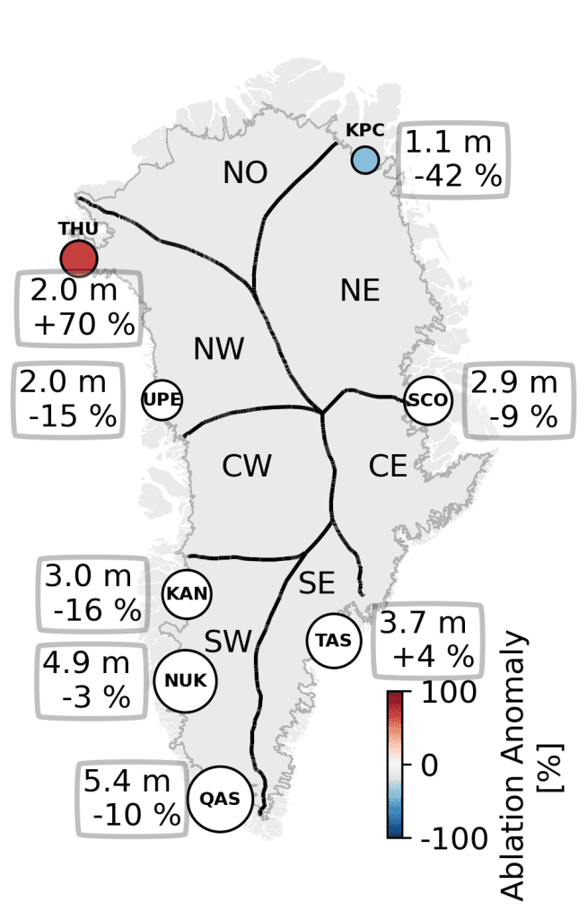
In-situ ablation measurements provide a sense of the integrated outcomes of the season’s surface conditions and weather events. For the ablation season measured between 1 January and 25 August 2022, PROMICE measurements around the ice sheet margin indicate substantial positive and negative anomalies, depending on region. Summing across the full ice sheet, however, regional variations broadly offset each other, with average ablation for the ice sheet as a whole (Fig. 4).
Solid ice discharge
Along with loss at the ice sheet surface via melt, the Greenland Ice Sheet loses ice through iceberg calving. This solid ice discharge occurs year-round from marine-terminating glaciers that act as conveyor belts to move ice from the ice sheet interior to the ocean (see essay Lessons from Oceans Melting Greenland). Measurements of solid ice discharge (see Methods and data) provide information on how ice sheet dynamics may be changing.
For 1991 through 2020, the average total discharge was ~471 ± 44 Gt per year, while average discharge during 2010 through 2019 was ~485 ± 46 Gt per year (Fig. 5). Solid ice discharge through October 2022 averaged 484 ± 45 Gt per year, with the largest contributions from the southeast, followed by the northwest. Ice discharge responds to changes slowly and is therefore a more stable mass balance term, relative to surface mass balance (Mankoff et al. 2021).

Unusual September melt events
Throughout this update we focused on the standard mass balance year, September 2021 through August 2022. September 2022, however, was very unusual. PROMICE weather stations recorded monthly temperature anomalies more than +1 standard deviation above the 1991-2020 reference period north of 65° latitude and above +2 standard deviations south of 65° latitude. Six DMI weather stations had record-breaking mean monthly September temperatures, including at Summit Station.
The ice sheet also experienced melt events that are unprecedented in the 44-year observational record. In early September, high pressure that was centered over the south of Greenland on 2 September brought a very warm and wet air mass northward from the central North Atlantic Ocean to along the ice sheet’s west side. This pulse of warm air then flowed eastward over the top of the ice sheet on 3 September, when +0.4°C was recorded at Summit Station, 3216 m above sea level, and 36% (592,000 km2) of the ice sheet experienced melt. The air mass then descended onto the eastern side of the ice sheet on 4-5 September, triggering further surface melt. In addition to bringing a very warm air mass, with daily temperature anomalies reaching +20°C, this event was accompanied by heavy rain and liquid water clouds (which enhance surface melt) over the western ablation zone. PROMICE weather station measurements detected rainfall at South Dome (2900 m above sea level) and substantial rain in coastal west Greenland (e.g., 32 mm within 24 hours at a QAS transect station, see Fig. 4). Later, on 26 September, the Greenland Ice Sheet experienced record melt extent for the second half of September as a result of the remnants of Hurricane Fiona, when ~15% (245,000 km2) of the surface experienced melting.
Both melt events were followed by below-freezing temperatures, refreezing meltwater at the top of the snowpack and favoring the formation of ice lenses. By creating a barrier to downward meltwater percolation, ice lenses reduce the snowpack’s capacity to retain new meltwater in future summers (MacFerrin et al. 2019). Thus, we must wait to observe the full influence that these September melt events will have on Greenland Ice Sheet mass loss.
Methods and data
Total mass change is measured indirectly by the GRACE (Gravity Recovery and Climate Experiment, 2002-17) and GRACE-FO (Follow On, 2018-present) satellite missions by detecting gravity anomalies (Fig. 1). Technical Notes are hosted at https://podaac-tools.jpl.nasa.gov/drive/files/allData.
Direct weather observations are provided via 15 Danish Meteorological Institute (DMI) weather stations with records beginning from 1784 (Nuuk) to 1991 (Summit) and 8 automatic weather station transects from the Programme for Monitoring of the Greenland Ice Sheet (PROMICE) at the Geological Survey of Greenland and Denmark (GEUS). DMI stations are located on land, with Summit data provided by NOAA GEOSummit. PROMICE transects, located on the ice sheet, also provide surface ablation (following van As et al. 2016; Fig. 4). A high temporal resolution solid ice discharge product is also generated by PROMICE using ice velocity (from MEaSUREs and Sentinel-1), ice thickness (from BedMachine v4), and ice density (following Mankoff et al. 2020; Fig. 5). Surface melt duration and extent measurements are derived from daily Special Sensor Microwave Imager/Sounder (SSMIS) 37 GHz, horizontally polarized passive microwave radiometer satellite data (Mote 2007; Fig. 2).
NASA MODIS satellite data provide multi-decadal albedo monitoring (Box et al. 2017). The Sentinel-3 SICE product is used to monitor bare ice area (Kokhanovsky et al. 2020; Wehrlé et al. 2021; Fig. 3).
Acknowledgments
Data from the Programme for Monitoring of the Greenland Ice Sheet (PROMICE) were provided by the Geological Survey of Denmark and Greenland (GEUS) at https://www.promice.dk. T. Moon was supported by the University of Colorado Boulder Cooperative Institute for Research in Environmental Sciences (CIRES). M. Tedesco was supported by National Science Foundation ANS #1713072, National Science Foundation PLR-1603331, NASA MAP #80NSSC17K0351, NASA #NNX17AH04G, and the Heising-Simons Foundation. T. Mote was supported by National Science Foundation #1900324. Sentinel-3 SICE data processing via PolarView.org is made possible by the European Space Agency (ESA) Network of Resources. Summit Station is owned and operated by the National Science Foundation Office of Polar Programs with permission from the Government of Greenland.
References
Box, J. E., D. van As, and K. Steffen, 2017: Greenland, Canadian and Icelandic land ice albedo grids (2000-2016). GEUS Bull., 38, 53-56, https://doi.org/10.34194/geusb.v38.4414.
Hopwood, M. J., and Coauthors, 2020: Review article: How does glacier discharge affect marine biogeochemistry and primary production in the Arctic? Cryosphere, 14, 1347-1383, https://doi.org/10.5194/tc-14-1347-2020.
Kokhanovsky, A., J. E. Box, B. Vandecrux, K. D. Mankoff, M. Lamare, A. Smirnov, and M. Kern, 2020: The determination of snow albedo from satellite measurements using fast atmospheric correction technique. Remote Sens., 12, 234, https://doi.org/10.3390/rs12020234.
MacFerrin, M., and Coauthors, 2019: Rapid expansion of Greenland’s low-permeability ice slabs. Nature, 573, 403-407, https://doi.org/10.1038/s41586-019-1550-3.
Mankoff, K. D., A. Solgaard, W. Colgan, A. P. Ahlstrøm, S. A. Khan, and R. S. Fausto, 2020: Greenland ice sheet solid ice discharge from 1986 through March 2020. Earth Syst. Sci. Data, 12, 1367-1383, https://doi.org/10.5194/essd-12-1367-2020.
Mankoff, K. D., and Coauthors, 2021: Greenland ice sheet mass balance from 1840 through next week. Earth Syst. Sci. Data, 13, 5001-5025, https://doi.org/10.5194/essd-13-5001-2021.
Morlighem, M., and Coauthors, 2017: BedMachine v3: Complete bed topography and ocean bathymetry mapping of Greenland from multibeam echo sounding combined with mass conservation. Geophys. Res. Lett., 44(21), 11051-11061, https://doi.org/10.1002/2017GL074954.
Mote, T. L., 2007: Greenland surface melt trends 1973-2007: Evidence of a large increase in 2007. Geophys. Res. Lett., 34, L22507, https://doi.org/10.1029/2007GL031976.
Mouginot, J., and Coauthors, 2019: Forty-six years of Greenland ice sheet mass balance from 1972 to 2018. P. Natl. Acad. Sci., 116(19), 9239-9244, https://doi.org/10.1073/pnas.1904242116.
Ryan, J. C., L. C. Smith, D. van As, S. W. Cooley, M. G. Cooper, L. H. Pitcher, and A. Hubbard, 2019: Greenland ice sheet surface melt amplified by snowline migration and bare ice exposure. Sci. Adv., 5, eaav3738, https://doi.org/10.1126/sciadv.aav3738.
van As, D., R. S. Fausto, J. Cappelen, R. S. van de Wa, R. J. Braithwaite, H. Machguth, and PROMICE project team, 2016: Placing Greenland ice sheet ablation measurements in a multi-decadal context. GEUS Bull., 35, 71-74, https://doi.org/10.34194/geusb.v35.4942.
Wehrlé, A., J. E. Box, A. M. Anesio, and R. S. Fausto, 2021: Greenland bare ice albedo from PROMICE automatic weather station measurements and Sentinel-3 satellite observations. GEUS Bull., 47, 5284, https://doi.org/10.34194/geusb.v47.5284.
February 14, 2023